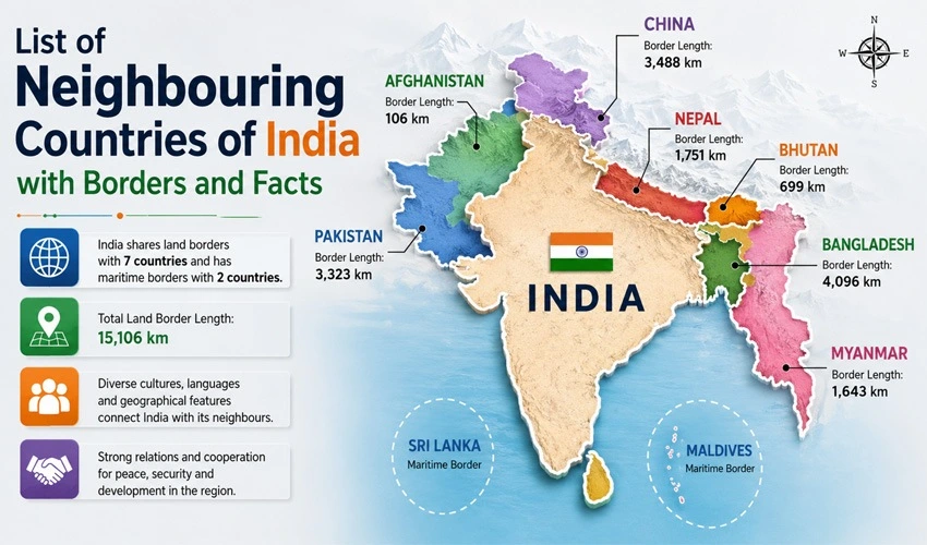
India occupies a unique geographic position in South Asia, bordered by a diverse mix of nations across land and sea. With one of the longest international land border networks in the world, India shares boundaries with several countries that differ dramatically in size, culture, and political history. Understanding these neighbouring countries, the states through which their borders pass, and the historical or geopolitical context behind each boundary offers valuable insight into India’s strategic position on the subcontinent. This article provides a complete, easy-to-follow list of India’s neighbouring countries, along with border details and important facts about each relationship.
India’s Total Land Border
India shares a land border of approximately 15,200 kilometers with seven countries, making it one of the longest land border networks of any nation. In addition to these land borders, India also shares maritime boundaries with a few more countries via the Indian Ocean, Arabian Sea, and Bay of Bengal. Altogether, India’s neighbours fall into two broad categories: countries connected by land borders and countries connected primarily through maritime boundaries.
Below is a detailed breakdown of each neighbouring country, organized by the length of the shared border and accompanied by key facts.
1. Bangladesh
Bangladesh shares the longest land border with India, stretching approximately 4,096 kilometers. This border passes through five Indian states: West Bengal, Assam, Meghalaya, Tripura, and Mizoram. The Bangladesh border is notable for its complex geography, including numerous enclaves that existed for decades due to historical land boundary agreements dating back to the partition era.
A landmark resolution came in 2015 when India and Bangladesh implemented the Land Boundary Agreement, which exchanged more than 150 small enclaves between the two countries, finally simplifying a boundary that had confused residents and administrators for generations. The border also passes through the Sundarbans, the world’s largest mangrove forest, which is shared between the two nations and is home to the Bengal tiger.
Beyond the border itself, India and Bangladesh share deep historical, linguistic, and cultural ties, particularly through the Bengali language and the shared history of the 1971 Bangladesh Liberation War, in which India played a significant supporting role.
2. China
India shares a border of roughly 3,488 kilometers with China, making it the second-longest land border India maintains with any neighbour. This border, often referred to as the Line of Actual Control (LAC) due to the absence of a mutually agreed and demarcated boundary, passes through the states of Jammu and Kashmir (specifically Ladakh), Himachal Pradesh, Uttarakhand, Sikkim, and Arunachal Pradesh.
The India-China border remains one of the most sensitive and closely monitored boundaries in the world. Disputes over specific sections, particularly in the Aksai Chin region and parts of Arunachal Pradesh, have led to historical conflicts, including the 1962 Sino-Indian War, and continue to generate periodic tension, including notable standoffs in the Galwan Valley and other high-altitude sectors. Despite these tensions, both countries maintain designated border trade points and continue diplomatic engagement to manage the boundary.
3. Pakistan
The India-Pakistan border spans approximately 3,323 kilometers and is one of the most heavily militarized borders in the world. It passes through the Indian states of Jammu and Kashmir, Punjab, Rajasthan, and Gujarat. This border includes the Line of Control (LoC), which separates Indian-administered Kashmir from Pakistan-administered Kashmir, and the International Border, which is more formally demarcated in the Punjab, Rajasthan, and Gujarat sectors.
The Radcliffe Line, drawn in 1947 during the partition of British India, forms the historical basis for much of this boundary. The border has witnessed multiple wars and conflicts since independence, including confrontations in 1947, 1965, 1971, and the Kargil conflict of 1999. Wagah, located near Amritsar in Punjab, hosts the well-known daily retreat ceremony at the border crossing, drawing large crowds from both sides for its ceremonial ritual involving synchronized marching and flag lowering.
4. Nepal
India shares an open border of approximately 1,751 kilometers with Nepal, passing through five Indian states: Uttar Pradesh, Bihar, West Bengal, Sikkim, and Uttarakhand. Unlike most of India’s other land borders, the India-Nepal border is largely open, allowing citizens of both countries to cross freely without visas or passports, a provision rooted in the Indo-Nepal Treaty of Peace and Friendship signed in 1950.
This open border arrangement reflects the deep cultural, religious, and familial ties between the two nations, with many families having relatives on both sides of the boundary. The border passes through diverse terrain, ranging from the Terai plains to Himalayan foothills, and includes important religious and pilgrimage routes connecting Hindu and Buddhist sites in both countries.
5. Myanmar
India’s border with Myanmar (formerly Burma) extends roughly 1,643 kilometers and passes through four northeastern Indian states: Arunachal Pradesh, Nagaland, Manipur, and Mizoram. This border runs through dense forested and mountainous terrain, making it one of the more remote and less accessible boundaries India maintains.
The India-Myanmar border is significant for regional connectivity projects, most notably the India-Myanmar-Thailand Trilateral Highway, aimed at boosting trade and connectivity between South Asia and Southeast Asia under India’s broader “Act East” policy. The border also has a free movement regime for tribal communities living along the boundary, allowing limited cross-border movement for local residents due to shared ethnic ties, particularly among Naga and Chin communities.
6. Bhutan
The India-Bhutan border stretches approximately 699 kilometers and passes through four Indian states: Assam, West Bengal, Sikkim, and Arunachal Pradesh. India and Bhutan maintain one of the most cordial and cooperative relationships among all of India’s neighbours, underpinned by a long-standing Treaty of Friendship first signed in 1949 and updated in 2007.
Unlike several of India’s other borders, the India-Bhutan boundary has remained relatively free of conflict, and India plays a significant role in supporting Bhutan’s hydropower development, infrastructure, and economic growth. The Doklam Plateau, located near the India-Bhutan-China tri-junction, has occasionally become a point of geopolitical tension, most notably during the 2017 Doklam standoff between Indian and Chinese forces, which occurred in territory claimed by both Bhutan and China.
7. Afghanistan
India shares a very short and disputed border of approximately 106 kilometers with Afghanistan, located in the Pakistan-administered Gilgit-Baltistan region, specifically bordering the Wakhan Corridor. Because this boundary lies within territory under Pakistan’s administrative control, the India-Afghanistan border is not accessible for direct movement and remains largely nominal in practical terms.
India does not administer this border directly due to Pakistan’s control over the intervening territory, but the boundary is officially recognized by India as part of the original Jammu and Kashmir state prior to partition. Despite the lack of a functional physical border, India and Afghanistan maintain historical, cultural, and diplomatic ties, including India’s involvement in infrastructure and development projects within Afghanistan over past decades.
Maritime Neighbours of India
In addition to its seven land-bordering neighbours, India shares maritime boundaries with a few additional countries, connected via surrounding seas rather than physical land borders.
Sri Lanka
Separated from India by the Palk Strait and the Gulf of Mannar, Sri Lanka lies just off the southeastern coast of Tamil Nadu. The narrowest point between the two countries is only about 30 kilometers, and the maritime boundary was formally established through agreements signed in the 1970s. Adam’s Bridge, also known as Rama Setu, is a chain of limestone shoals connecting Pamban Island near India’s coast to Mannar Island near Sri Lanka, and holds religious significance in Hindu tradition as well as geological interest.
Maldives
Located southwest of India’s Lakshadweep Islands, the Maldives shares a maritime boundary with India in the Arabian Sea and Indian Ocean. India and the Maldives maintain close diplomatic, economic, and security cooperation, given the archipelago’s strategic location along key international shipping lanes.
Indonesia
India shares a maritime boundary with Indonesia near the Andaman and Nicobar Islands, India’s easternmost territory in the Bay of Bengal. This maritime boundary, though less discussed than India’s other borders, holds strategic importance due to its proximity to the Strait of Malacca, one of the world’s busiest shipping corridors.
Thailand
India also shares a maritime boundary with Thailand near the Andaman Sea, further reinforcing the strategic significance of India’s island territories in facilitating regional connectivity and maritime cooperation with Southeast Asia.
Summary Table of India’s Land-Bordering Neighbours
To simplify the information above, here is a quick summary of India’s seven land-bordering neighbours, ordered by border length:
- Bangladesh – Approximately 4,096 km, bordering West Bengal, Assam, Meghalaya, Tripura, and Mizoram
- China – Approximately 3,488 km, bordering Ladakh, Himachal Pradesh, Uttarakhand, Sikkim, and Arunachal Pradesh
- Pakistan – Approximately 3,323 km, bordering Jammu and Kashmir, Punjab, Rajasthan, and Gujarat
- Nepal – Approximately 1,751 km, bordering Uttar Pradesh, Bihar, West Bengal, Sikkim, and Uttarakhand
- Myanmar – Approximately 1,643 km, bordering Arunachal Pradesh, Nagaland, Manipur, and Mizoram
- Bhutan – Approximately 699 km, bordering Assam, West Bengal, Sikkim, and Arunachal Pradesh
- Afghanistan – Approximately 106 km, bordering the disputed Gilgit-Baltistan region
Why Understanding India’s Borders Matters
India’s borders are far more than lines on a map. They shape trade relationships, cultural exchange, security policy, and even the everyday lives of millions of people living in border regions. Open borders like the one shared with Nepal foster deep social integration, while heavily militarized borders like the one with Pakistan reflect decades of complex political history. Disputed boundaries with China continue to influence India’s foreign policy and defense strategy, while cordial partnerships with Bhutan demonstrate how border relationships can also be built on cooperation and mutual development rather than conflict alone.
For students, travelers, or anyone interested in geopolitics, understanding this network of borders offers a window into how geography, history, and diplomacy intersect to shape one of the world’s most strategically significant regions.
Conclusion
India’s position in South Asia places it at the crossroads of diverse cultures, histories, and political relationships, reflected vividly in its extensive network of international borders. From the long, culturally intertwined boundary with Bangladesh to the short but symbolically significant boundary near Afghanistan, and from the open, treaty-based border with Nepal to the tense, militarized frontier with Pakistan, each neighbouring relationship tells its own story. Added to this land network, India’s maritime boundaries with Sri Lanka, the Maldives, Indonesia, and Thailand further underscore the country’s broad geographic and strategic footprint across South Asia and the wider Indian Ocean region.


More Stories
PogoLinks: Explore Trending Content in One Place
25 Types of Bras; Every Woman Should Know About
5 Party Details That Help Guests Stay Longer and Enjoy More